The Network RTK precise positioning method is one of the most widely used one in surveying practice. To gain the cm accuracy is based on a kind of „cooperation” of independent sub-systems like the GNSS satellite segment, the RTK base station network operator, the mobile telecommunication service provider and finally the rover producer. This set-up, however, might carry some risks for the user as it can and actually does happen sometimes that one or more of the mentioned players may fall out of the game temporarily or even they don’t exist at all. To avoid increasing costs (wasting time, returning twice to the field, or establishing an expensive local network, etc.) in such a situation Leica Geosystems offers the SmartLink and SmartLink Fill services. These solutions are based on the so-called real-time PPP (Precise Point Positioning) technique where the corrections are generated from a network of continuously operating global reference stations and delivered by an augmentation satellite system to the end user. A „classical” PPP solution, however, needs a postprocessing, a certain convergence time to achieve the required accuracy. So, the required time and achievable accuracy are the core questions by users to see if the method is really a reliable supplement of RTK field practice. To answer these questions the Óbuda University, Alba Regia Technical Faculty, Institute of Geomatics led by Dr. György Busics and our support engineer Tamás Péter carried out a field test resulting in the confirmation of expectations.
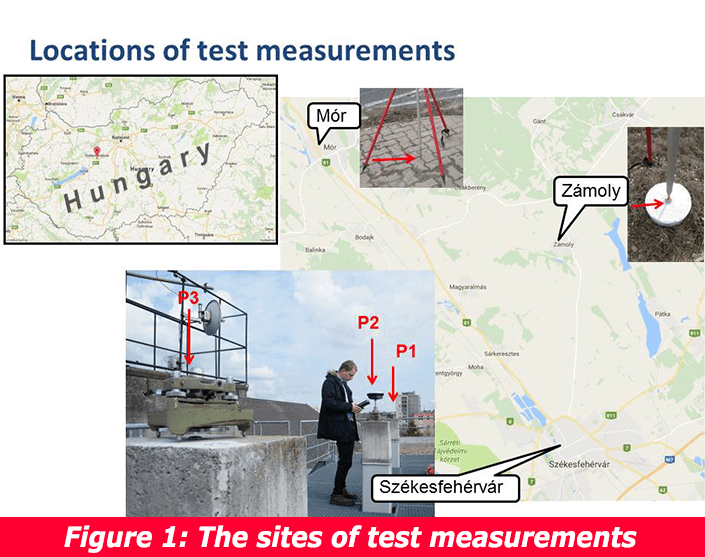
For the test they used three base points situated in Székesfehérvár, Zámoly, and Mór (Figure 1.). In the first tests, they compared post processing PPP results with real-time PPP. In the second tests, they compared RTK method with real-time PPP. All the observations were carried out with Leica GS16 receivers and Leica Captivate CS20 controller. In Székesfehérvár, they used all the three pillars (P1, P2, P3) on the top of the campus.
Testing Leica SmartLink
Leica SmartLink service is used for situations when Network RTK corrections are not available for a longer period (typically for more than 10 minutes) or RTK services are not available at all (we work on a site where there is no RTK correction service or there might not be even a reference point network, so-called active network). In the latter case, one of our options is to establish a local base point network or we use a post processing PPP method. Both might be costly and/or time-consuming. Therefore real-time PPP techniques – e.g. SmartLink – can be solutions if accuracy meets the expectations. That is what was tested in the first round.
 On point P3 a „conventional” PPP measurement was applied. For reaching cm accuracy they needed to use a 24 hours observation period with post processing followed by gaining the precise satellite orbit data from IGS service (that takes additional long time). By contrast, Leica SmartLink as a real-time PPP technique doesn’t need long measurement period yet it is able to provide cm accuracy. In Figure 2 we can see the linear distance difference between the 24 hours post processed PPP coordinates and Leica SmartLink method.
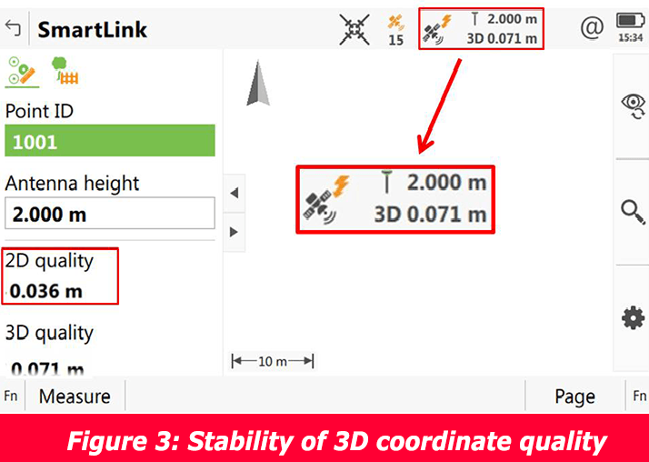 We can see that not only did the Leica SmartLink manage to gain fix position within 45 minutes, but the quality of coordinates could be maintained with high stability during the whole period (Figure 3.). It is important to highlight that we can acquire fix position with Leica SmartLink within a shorter time provided even better conditions (number of satellites, constellation, errors to resolve).
To double check the test results there was a 6 hours comparative PPP observation on P 1(Figure4) and another measurement on P3 at the end of the day (Figure 5).

In case of this latter one, Leica SmartLink managed to gain fix position within 30 minutes.

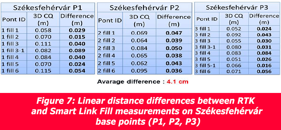
Finally, let’s see the results when comparing RTK measurements with Leica SmartLink observations (Figure6):

Testing Leica SmartLink Fill
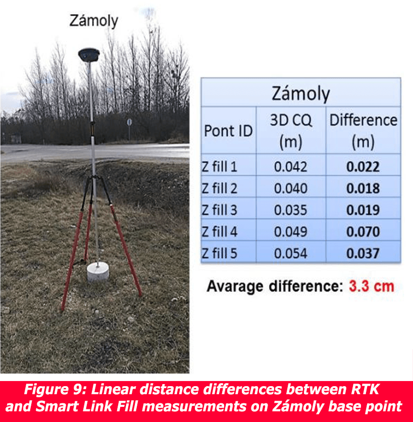
The Leica SmartLink Fill is supposed to apply when we use Network RTK corrections, but for any reason (e.g. temporary breakdown of RTK services, mobile telecommunication coverage problems, etc.) the correction services are not accessible for a shorter period (typically for maximum 10 minutes) but we don’t want to cease our work. The results were as follows:

To sum it up we can see that Leica SmartLink and SmartLink Fill services provide a stable solution within acceptable accuracy ranges even with the implication of transformations. The absolute accuracy of SmartLink predominantly depends on a precise reference frame transformation. The relative precision of SmartLink is far better. SmartLink Fill does not require a reference frame transformation and is linked to the base station coordinates. Real-time PPP, therefore, can be a cost-effective solution when we have no access for RTK corrections for a limited period (SmartLink Fill) or where we don’t have the „conventional” positioning infrastructure at all (SmartLink).

We would like to express our special thanks to Dr. György Busics (Óbuda University, Alba Regia Technical Faculty, Institute of Geomatics) and our colleague Tamás Péter (ECE regional support engineer) for this test.
For more information on SmartLink and SmartLink Fill, feel free to consult our related Leica Geosystems Blog.
Best regards,
The Leica Geosystems Hungary Team

You must be logged in to post a comment.